Brief Introduction
The excavation site at Rakhigarhi , Haryana, India is the earliest civilization of South Asia which flourished around 3000 to 4000 BCE. It is one of the five largest archaeological sites of the Harappan civilization. The first enlarged data was published by Suraj Bhan in 1969 AD in which he recorded mature Harappan tradition in town planning, architecture,and arts and crafts at Rakhigarhi.
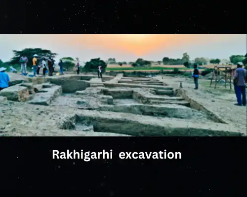
Rakhigarhi site consists of 11 excavation mounds including all residential and burial sites. This site was excavated by Shri Amrendra Nath of Archaeological Survey of India.
It is located 27 km away from the Ghaggar river in the Ghaggar – Hakra river plain. The downstream of the joint flow of Saraswati and Drishadvati river is known as hakra . The massive alluvial land combined with a network of hydrological sources was a crucial ergonomic factor for settlement in the Saraswati-Drishadvati valley . An epigraph of the 10th century CE from Pehoa cites about an eastern branch of the Saraswati while a text contemporary to the said epigraph apprises that there was an effective Canal irrigation network in this area.
The site at Rakhigarhi was subjected to excavation during the year 1997-98 , 1998-99, 1999-2000 .The excavation site is divided into 7 archaeological mounds as RGR-1 , RGR-2, RGR-3, RGR-4, RGR-5, RGR-6 and RGR-7. Out of these seven mounds , RGR-1, RGR-2, RGR-6 talk about the Pre-formtive stage followed by the early Harappan settlement.Here , RGR7 talk about necropolis.
It is interesting to note that out of 6650 objects examined , 228 have been reported from RGR6 which has given a sequence of culture of the early farmers of the pre-formtive stage assignable to Circa 5th Millennium BCE succeeded by the early Harappans. RGR-5 revealed the bone making industry. RGR7 reveals the evidence of Harappan cemetry.
The study of Rakhigarhi includes factors like climate, landform ,drainage ,flora and fauna and soil. The study areas lie in the flood Plains of Saraswati-Drishadvati basin.
Exploration conducted in the Saraswati- Drishtivati divide reveals cluster of settlement of the protohistoric period which indicates extensive harnessing of the riparian plain by canalising water sources.
The relics of settlement have been found dotted along the abundant canals and streams which carries a testimony to the knowledge of water harnessing and irrigation of agricultural fields in the Saraswati-Drishadvati divide.
Excavation
The main purpose of excavating at Rakhigarhi was to decide whether the people living there were of the true Harappan settlement or not. And also were they of the same urban discipline and enjoyed the same material prosperity as in the metropolitan centres of Harappa and Mohenjodaro or not ?
After excavating , it was found that there must have been keen planning of the town and the sanitary system discussed in depth by the well-advanced skilled people before execution of it .
The fertility of the land and Drishadvati channel ( now dried up) had compelled the Harappan to settle down at Rakhigarhi.
The town planning must have included all the Civic amenities. It had laid out a platform for Streets and drains, the separation of industrial areas from industrial localities, the provision of public wells, the arrangements of houses in rows, the erection of fortification walls of uniform width and more than all the construction of the grainary, religious podium, etc.
A genius mind with extraordinary skills only had the capabilities to execute precisely the way it had been planned. Rakhigarhi had played a significant role in enriching Harappan Civilization in all scientific and technical terms.
The excavation also revealed that there was the existence of foreign material at Rakhigarhi which indicates that the site was participating in a long distance trade or exchange system. It further gives the evidence of highly specialised craft production for intersite and manufacturing of items for local consumption.
The faunal data accessed at the site echo man- animal interdependency and their food habits. A large percentage of cattle and other domesticated animal bones indicates availability of widespread pastoral land that was used for grazing as well as for husbandry purposes.
Discovery
Arts and craft
The soil found there was Sandy loam which was used to make clay pots, terracotta objects and house building materials. The presence of Palaeo ponds within the periphery and in the vicinity of the site indicates old relics of Palaeo channels.
A few objects made on gray sandstone cobbles are also found within the catchment area of Rakhigarhi. some of Terracotta crucibles found at the site which suggest the copper melting activity. Gold ornaments were also found which include beads,bangles, pendants, rings, coiled spring, fillet, foil etc. Also a lead ingot of plano-convex shape inscribed on both the sides were found.
It should be noted that steatite was a very popular mineral of the Harappan at Rakhigarhi. Nearly 10% of the beats were made from steatite. Another important material was faience.
A faience working kiln is found from RGR-2 of Rakhigarhi along with a large number of finished objects such as bangles and beads. Beads of semi precious stones having a reddish Orange variety of agate known as Carnelian have been found at Rakhigarhi.
The painted motifs were loop, baniyan leaves, star pattern, horizontal , peepal leaves ,net type paintings. Peepal leave was the most dominant motifs of that period.
Construction
For inflammable construction of buildings at Rakhigarhi, either Sundried-bricks or backed bricks were used. The bricks were monded and made out of fine silty clay, kankorise clay and black cotton clay.
For the drainage system, bath parts from kiln fired bricks were used. The use of chamfered bricks was only for the drainage system.
They used heavy stone block as saddle quarn, bead polisher. They used to put heavy stone block as steps in front of their doorway. And another sandstone material of cubical, squarish chart were used as a weight measurement.
Normally, clay mortars used as construction work but time sand mortar and a water chute-lime sand were also used. The wall plastery was done through clay mixed with other elements.
Crops
The crops which were sawn in winter were Barley ,wheat, peas, lentils, chick-peas etc. While in summer rice,millets, dates ,grams, cotton etc. There are also pieces of wattle and daub from the lower levels at Rakhigarhi embedded with rice husks. But the main crops were Barley and wheat which were taken by the Harappan farmers of Rakhigarhi.
The denigration in the quality of soil has taken place due to excessive agriculture which was not there when the Drishadvati River was active till Circa 2000 BCE.
Religion
There is evidence of fire worshiping after finding the podium where a four fire after in a series has been unearthed. It suggests metaphysical aspects of the religion. Finding of some elongated type red Stone pieces proved their rituals rites.
In RGR-1, there are presence of Yoni-Linga style fire altars. It is circular and having one end with oblong structure and in the centre of the structure, one linga type which is more hard suggesting made out of kankarise soil. They used to worship fire, Linga, and Yoni.
The excavation also gives hints towards the sacrificial chamber. In these Chambers a large amount of sheep, goat bones and small pot fragment, offering charred seeds with characoal are found.
Soil fertility
The fertility of the soil around rakhigarhi is categorised into the below series.
1.Jallopur series -Yellowish brown, Sandy loam
2.Ninanda series- pale brown and brown loamy sand, Sandy loam, brown to dark brown non-saline.
3.Rawalwas series- brown, loamy sand in upper Horizons, yellowish to dark yellowish Brown in lower horizons.
4.Behel series- yellowish brown Sandy in upper Horizon and brown to dark yellowish , non-saline, nonsodic, nonsticky and nonplastic in lower Horizons.
5.Shamri series – white incrustation of salt, brown colour and loamy sand texture in upper Horizon. In lower Horizons, have brown to yellowish brown in colour and Sandy loam to loam in texture.
Each of these categories are specified in vegetation.
Conclusion :
It’s a harsh reality that these kinds of excavation sites are totally ignored by the state government as well as the central government. Sometimes people living around these sites used to sell the finding materials during excavation in the open market to gain handsome money . No special attention is given to these archeological sites. These sites which can give us the most surprising knowledge of our existence are ignored for political benefits.